2026.0.01
ImprovementLuciadRIA
RIA-5455
Editor used in EditController and
CreateController using a getter. This new functionality is used
SampleCreateController inside ria-toolbox-core,
to correctly initialize the parent controller when a delegate controller is provided.
ImprovementLuciadRIA
RIA-4171
Bug fixLuciadRIA
RIA-5438
Bug fixLuciadRIA
RIA-5449
Bug fixLuciadRIA
RIA-5441
GraphicsEffects.antiAliasing would result in the map
having a black background rather than a transparent one.
Bug fixLuciadRIA
RIA-5436
2026.0
2026.0
New featureLuciadRIA
RIA-5227
OGCFilterEncoder.createOGCFilterEncoder to create an encoder
for your OGCExpression based on the correct WFSVersion.
The encoder will use the proper OGC XML filter format.
New featureLuciadRIA
RIA-4988
TileSet3DLayerConstructorOptions#attributeFilter property allows filtering attributes of HSPC datasets.
See Tuning performance and visual quality of point clouds.
New featureLuciadRIA
RIA-5349
WFSFeatureStoreCreateOptions#splitBBOX allows you to choose whether the BBOX filter should
be split when it contains the antimeridian. When set to true, two BBOX filters will be created and combined with
an OR operator. When set to false, a single BBOX filter crossing the antimeridian will be created.
New featureDefense Symbology
Partial support for the military standard APP-6E has been added.
It is now possible to create and visualize MilitarySymbol instances for the
APP-6E military standard.
APP-6E support is currently limited to the Cyberspace icon symbols. All supported symbol sets are listed in the supported military standards article .
To visualize the supported symbols, you can run the "Military Symbology Overview" sample, located in samples/symbology/allsymbols within the release directory.
ImprovementLuciadRIA
Editor that not only edits the shape of a feature, but also its properties.
EditHandle and EditController can now emit EditProperty events.
By default, these events are not emitted. You need to implement this behavior in your custom editor.
You can use this event to create "edit property" undoables in your application.
For more information, check the API documentation of EditHandle, EditController, and their new "EditProperty" events.
ImprovementLuciadRIA
UndoManager now emits "Undo" and "Redo" events when an undo or redo operation is performed.
Previously, only change events for the undo and redo stack were emitted.
You can use these events to perform custom actions in your application when an undo or redo operation occurs.
ImprovementLuciadRIA
RIA-5382, RIA-4993
IconStyle.transparency and ParameterizedPointPainterConstructorOptions.transparency flags respectively.
ImprovementLuciadRIA
ImageCaptureUtil to ria-toolbox-core to support reliable
map image capture using GPU rendering.
ImprovementLuciadRIA
Infinite-Grid tool to the LuciadRIA Toolbox. It renders a GPU-accelerated, infinite reference grid to 3D maps.
See toolbox/ria/infinite-grid/README.md for more information.
ImprovementLuciadRIA
PickController, and its subclasses SelectController and HoverController, now support asynchronous picking.
You can enable asynchronous picking by setting the new async option on the controller to true.
For more information, check the API documentation of PickController, SelectController and HoverController.
ImprovementLuciadRIA
RIA-4736
Camera.viewProjectionMatrix to retrieve the camera’s view–projection matrix.
ImprovementLuciadRIA
ImprovementLuciadRIA
UrlStore queries.
ImprovementLuciadRIA
RIAMap now offers asynchronous versions of its picking methods.
The methods take the same arguments as their synchronous counterparts and return a Promise.
Here is a list of the new methods:
RIAMap.pickClosestObjectAsyncRIAMap.pickClosestObjectRectangleAsyncRIAMap.pickAtAsyncRIAMap.pickAtRectangleAsync
ImprovementLuciadRIA
KMLCodec now decodes ExtendedData into
KMLFeature.properties.extendedData. Supported sources:
Data, SchemaData and foreign-namespace elements.
ImprovementLuciadRIA
GoogleLayer
has been removed from the API.
It's recommended to use GoogleMapsTileSetModel instead.
Check the Differences between
GoogleMapsTileSetModel, GoogleImageModel and GoogleLayer
article for more information.
ImprovementLuciadRIA
RIA-5128
@luciad/ria/util/License.js API.
Existing applications that already configured a LuciadRIA license will continue to work as before.
For the optional modules, the license check is performed also at the following API entry points:
-
Constructive Geometry
ConstructiveGeometryFactory.createEllipsoidal()ConstructiveGeometryFactory.createSpherical()ConstructiveGeometryFactory.createCartesian()
-
Panoramics:
GeoCanvas.drawPanorama()
-
Military Symbology
SymbologyProvider.getSymbology()
ImprovementDefense Symbology
Bug fixLuciadRIA
RIA-5275
saveState() and restoreState() calls were not
properly
delegated in ComposedShapeEditor.
Bug fixLuciadRIA
Bug fixLuciadRIA
RIA-5387
Bug fixLuciadRIA
RIA-4344
RIAMap.maxMemoryUsageHint is now correctly applied after a
RIAMap.reboot triggered by GPU device loss. Previously, default settings were applied.
Bug fixLuciadRIA
RIA-4289
Bug fixLuciadRIA
RIA-4549
Upgrade considerationLuciadRIA
KMLUtil.createGroundOverlayLayer
now returns a promise for
FeatureLayer
(previously a promise for Layer).
Upgrade considerationLuciadRIA
Map implementation has been removed from the API.
Both Map and WebGLMap have been deprecated in favor of
RIAMap, which
leverages WebGPU for hardware-accelerated rendering.
It is no longer possible to create non-hardware-accelerated maps or WebGL-based maps.
To ease the transition, WebGLMap and Map are now both aliases for the
new RIAMap.
Any maps created with new Map() or
new WebGLMap()
will automatically instantiate WebGPU-powered RIAMap instances.
We recommend updating your code to use RIAMap directly.
Upgrade considerationLuciadRIA
Upgrade considerationLuciadRIA
EditController and CreateController
have been aligned with the EditSettings type.
To this end, the styles that were previously configured
on the options object have been moved to a styles property.
For example, the following code:
          const editController = new EditController(layer, feature, {
            handleIconStyle: {
              image: createSquare({
                width: 8,
                height: 8,
                fill: "white",
                stroke: "black",
                strokeWidth: 1
              })
            }
          });
        const editController = new EditController(layer, feature, {
          styles: {
            handleIconStyle: {
              image: createSquare({
                width: 8,
                height: 8,
                fill: "white",
                stroke: "black",
                strokeWidth: 1
              })
            }
          }
        });
Upgrade considerationLuciadRIA
RIAMap.pick methods report features from TileSet3DLayer anymore.
The new asynchronous picking methods do report these features and are the recommended approach.
To restore synchronous picking support for TileSet3DLayer,
enable the synchronousPicking flag in TileSet3DLayerConstructorOptions.
For more information, see Picking on 3D Tiles.
Upgrade considerationLuciadRIA
MapNavigator methods have been removed from the API.
Use the newer pan(), zoom(), rotate()
and fit() methods instead.
Upgrade considerationLuciadRIA
@luciad/ria-toolbox-map-borders component in the LuciadRIA Toolbox. It offers enhanced support for bordered maps, axis rendering, and custom border drawings.
For more information about this LuciadRIA toolbox component, refer to the How to draw a map with borders article.
For guidance with the migration from the previous API to the LuciadRIA Toolbox, refer to the Migrating to the map-borders component in the LuciadRIA Toolbox article.
Upgrade considerationLuciadRIA
-
Blending of (semi-)transparent colors now happens in linear color space. In previous LuciadRIA versions, it happened in gamma
color space (sRGB). This move solves blending artifacts, but it can make blended colors slightly
brighter. This is especially noticeable when rendering thin lines or thin text.
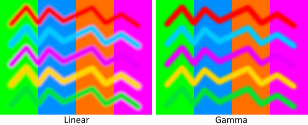
-
Texture sampling now happens in linear color space. In previous LuciadRIA versions, it happened in gamma color space (sRGB).
Like for blending, this move solves minor artifacts, but the texture sampling might look slightly differently
than before.
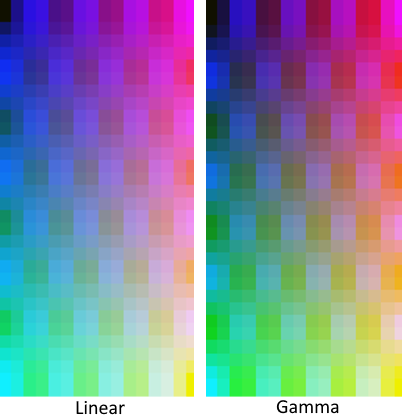
-
Lighting now happens in linear color space. In previous versions, it happened in gamma color space (sRGB).
This move results in a harder but more correct lighting gradient. It can make parts of the lit objects brighter
or darker than before.
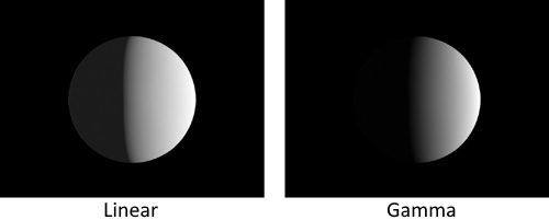
- Image-based lighting now correctly interprets the colors when using a PNG or JPEG as reflection map. In previous versions it interpreted these colors as linear colors, which made the lighting brighter than it should.
Upgrade considerationLuciadRIA
BloomEffect.
Instead, you can now configure a luminance threshold on each individual BloomStyle.
This means that bloom is now only applied to features for which a BloomStyle has been set.
Merely configuring a BloomEffect on a RIAMap will no longer have any
effect.
Upgrade considerationLuciadRIA
expected-lite: updated to version0.9.0glu: updated to version1.3+7libjpeg: updated to version9flibwebp: updated to version1.5.0
gladprotobufrapidxml-ns
Upgrade considerationLuciadRIA
-
The
RIAMap.webGLContextproperty has been removed. Has been removed in favor ofRIAMap.webGPUDevice, which means listening for WebGL context lost events is no longer supported. Instead, listen to WebGPU device loss events. See Dealing with WebGPU device losses for more information. -
A new event,
"WebGPUDeviceChanged", has been added to theRIAMapAPI. -
The RIAMap's
"PostRender"event now usesGPUTexture.
Upgrade considerationDefense Symbology
A framework dedicated to the editing of military symbology has been added to LuciadRIA. The LuciadRIA API now includes:
- The
MilitarySymbologyCreateController, to improve user experience and correctness when creating multi-pointMilitarySymboltactical graphic instances. - A
MilitarySymbologyEditControllerto improve user experience and correctness when editing multi-pointMilitarySymboltactical graphic instances. - A
MilitarySymbologyEditor. It is used under the hood of the new controllers, and ensures correct editing behaviour enforcing the necessary constraints for the different tactical graphics.
With the introduction of this dedicated military symbology editing framework, the previous default
editing mechanism using the ShapeEditor will break.
All tactical graphics will be editable as if they were plain Polyline shapes,
without any behavior specific to military symbology.
For more information about using this new editing framework, see the migration guide. For more information about the behavior of this new editor for different types of tactical graphics, see the creation and editing article.